GPS accuracy in running watches and activity trackers
GPS accuracy in running watches and activity trackers
GPS is an incredible technology. A device you can wear on your wrist is able to read radio signals sent from a series of satellites to calculate your exact position anywhere on the planet in just a few seconds.
But why do we even bother with it? What good is GPS in a running watch or activity tracker?
Years ago, accurately tracking an activity involved a stopwatch and some careful measuring on to-scale maps. How would you know how long it took you to run 5k if you didn’t have a precisely measured course (most likely a track) and a stopwatch?
Nowadays we have the means to do just that in real time using just a watch (or a phone) but there are other benefits both during and after a run.
Live telemetry
Data available at-a-glance to give real time speed, pace, distance and time, right on your wrist
You can easily track split times
Splitting a run into smaller chunks can help you see clearer trends, monitor progress in more detail and help to identify your strengths and weaknesses
Track performance over time
Keeping historic run data allows you to challenge yourself (or others via social activity sites) by trying to beat your previous efforts both in full routes or small segments, helping to see your improvements
Visualise the route on a map afterwards
Great for finding that path you went down or what was down the end of that lane you didn’t as well as just the general satisfaction of seeing your route mapped out
Track the run you did rather than the one you planned
What if you planned a route and missed a turning or a road you were planning on using was closed? You still ran (which is the most important thing) but you may find it hard to know how far you actually went
Get information on recommended rest and recovery
Newer watches can even give you estimates around rest and recovery, though only you will know how well they work for you (or if you even want to pay them any attention)
And GPS watches also tend to have other sensors built in to give you real time data on your current condition - heart rate (either via optical sensors in the watch or a separate chest strap), cadence, altitude, stride length - and can even be 24/7 fitness trackers, counting your daily steps and monitoring your sleep.
So… Data, it's all about the data!
We are collecting data on ourselves to monitor how well we are doing or if we are making progress and having it all logged so we can easily refer to it at a later data should we need. I love being able to easily see how far I have run this month/year or what my pace was on a course 6 months ago compared to today. Being able to drill down into a run I have just finished and check specific points can reveal a lot about your current fitness - That hill seemed hard, was it much steeper than I thought or was I just struggling today? Sure, this *could* all be done manually without GPS tracking but… Nope, not for me, I wouldn’t be tracking much with any decent level of accuracy if I had to do it all manually. And if I did it manually, no one is giving me kudos on Strava!
With all these advantages, it is tempting to use this little magical device as the definitive source-of-truth for data, both during and post-workout, and sometimes that might make you miss out on what you are working towards… Read on!
How GPS works
There is plenty of information online by far more knowledgeable people about how GPS works so I won’t go into much detail, but this is a quick rundown on how GPS works.
Far above us, over 20,000km in fact, there are 24 GPS satellites orbiting the earth each housing incredibly accurate timing devices called atomic clocks. The satellites each send radio signals to earth containing, amongst other things, the precise time that the signal was sent (using a timestamp from the atomic clocks). Those signals take just 70 milliseconds - that’s just 0.07 seconds - to reach us on earth! (well, actually between 67 and 86 milliseconds depending on the satellite’s position in the sky and your position on earth).
Your GPS device picks up these radio signals and based on the difference in the time taken for signals from different satellites to reach the device, it can determine its precise position using a method called trilateration.
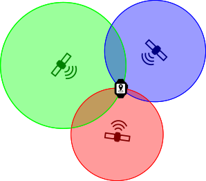 Example of trilateration, each of the red, green and blue satellites send out signals which are picked up by a GPS device. The radius of each circle indicates the time it takes for the signal to reach the device and the intersect point of all three is the calculated position of the device.
A GPS fix needs a minimum of 4 satellites (yes, TRI-lateration needs 4) but a device will use more if they are available for a more accurate position.
Things aren’t always ideal though as the system relies on these signals getting to the device at a consistent speed which means in a straight, uninterrupted line. This is often not the reality though. Tall buildings can bounce the signals around, adding valuable nanoseconds to the time delay before being reached by the GPS device and causing the timing calculations to be very slightly wrong. This can be enough to reduce the accuracy of the position or to calculate an incorrect position - Exactly what happens in a city when your GPS device struggles to keep your position properly. Tree cover is another example of where the signal can be blocked from direct line-of-sight and be the subject of less than perfect accuracy.
As a little bonus, GPS watches can use the radio signals to set their own time so you don’t have to!
Despite the how remarkable GPS technology is, we are so accustomed to using it in our day-to-day life that we often expect too much from it. Consumer GPS devices, such as those in phones or used in GPS fitness trackers, are accurate to around 5-10 metres.
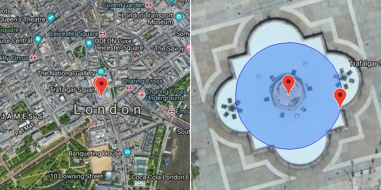
This image shows a circle with a radius of 10 metres. It looks very accurate on in the image on the left, bang on the west fountain in Trafalgar Square (if slightly obscured by the markers when viewed here). But the right image is zoomed in to show there is a margin for error - The actual position is somewhere within the fountain pool, not necessarily right in the middle. This level of accuracy is normal for a consumer GPS device.
We also have this ability to zoom in and analyse a route tracked by a GPS watch which, just like the sample circle above, can be overlaid onto maps and satellite imagery. At this point we can really see where minor inaccuracies make a difference.
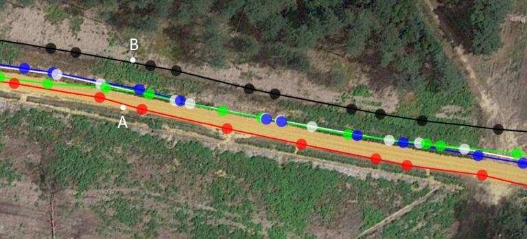
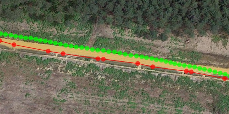
Above shows a section of a run, zoomed into a bit of pathway around 140m long that was run along multiple times (each colour represents a lap along the same path). As you can see, despite running the same path each time, the fact the GPS can position your to within 10 metres means the activity followed a slightly different track each time - None of them are wrong, they are all within expected levels of accuracy. The difference between points A and B is around 13 metres.
But it isn't always that way.
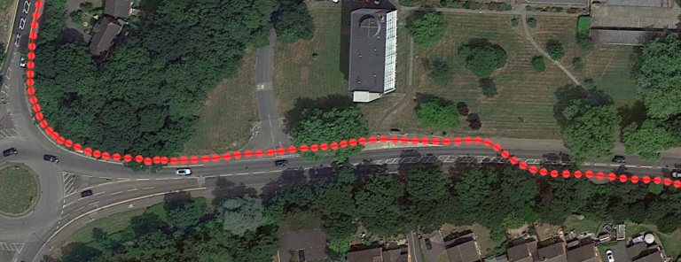
This section is on a path at the side of a road with ‘normal’ stuff like trees and buildings around and the accuracy was brilliant - It has me placed perfectly on the pathway around a corner then even crossing the road and continuing on the other path. If conditions are good, then your GPS device can be a very reliable source of data.
Tracking activities
GPS activity trackers measure distance travelled by a series of track points recorded at intervals during the activity which store the latitude and longitude along with a time stamp and some other metrics if they are available such as elevation, heart rate and cadence.
Devices can have the ability to record a track point every second, every set number of seconds or dynamically (where the device decides how often to record a point based on its internal sensors detecting changes in speed, direction, altitude, heart rate or anything else that it is capable of detecting - this is called smart recording in Garmin devices). With dynamic recording, the device is most likely still checking the GPS position more frequently in order to know if the position has changed in a way that is worth recording but only records the position when it needs to. Dynamic recording is normally set as the default where available.
Here we see the difference between smart recording track points (red) and 1 second interval track points (green). These were taken from different activities on different days, but this bit of the route was the same - It’s a pretty open, straight stretch so shouldn’t tax the GPS module too hard.
You can see the smart recording only stored 11 points in this view at uneven intervals versus the 45 that the 1 second interval recorded. 4 times as many points equals 4 times more storage space required which is primary reason for smart recording.
The most noticeable thing about this comparison is that although there was a big difference in the frequency of the track points, neither one was any more accurate than the other. That pathway is no more than 5 metres across at its widest so both runs were tracked well. Storage space was more of a concern a few years ago and with Bluetooth and Wi-Fi synching (so activities get synced immediately after finishing) together with increased storage space on devices, it is unlikely you will have any problems with storage on modern devices.
Measuring distances
If track points are just a position at a specific time, then that sequence of points needs to be converted to the distance travelled. This is done by simply working out the straight-line distance between two recorded track points to give the distance for that section, then the total distance the whole activity is the sum of all these small straight-line section distances. Changes in altitude also affect the distance travelled and is accounted for during distance calculations and can be applied in the device if has an altimeter or by software once imported/uploaded.
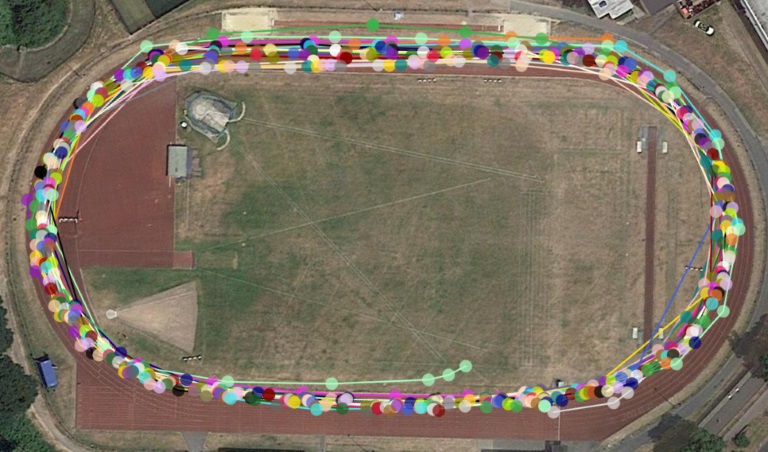
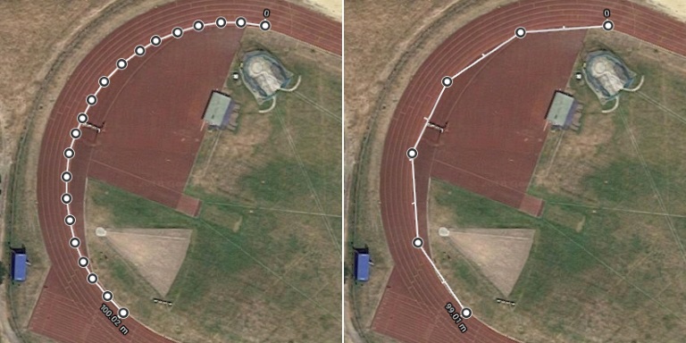
This is an example of part of a run around a standard running track. There are 25 laps here which makes it hard to see the detail but what you can see is that to track points were spread across a large percentage of the track, particularly on the bends but all laps are within a decent level of overall accuracy.
Let’s remove most of the laps so we have a clearer picture of what’s going on.
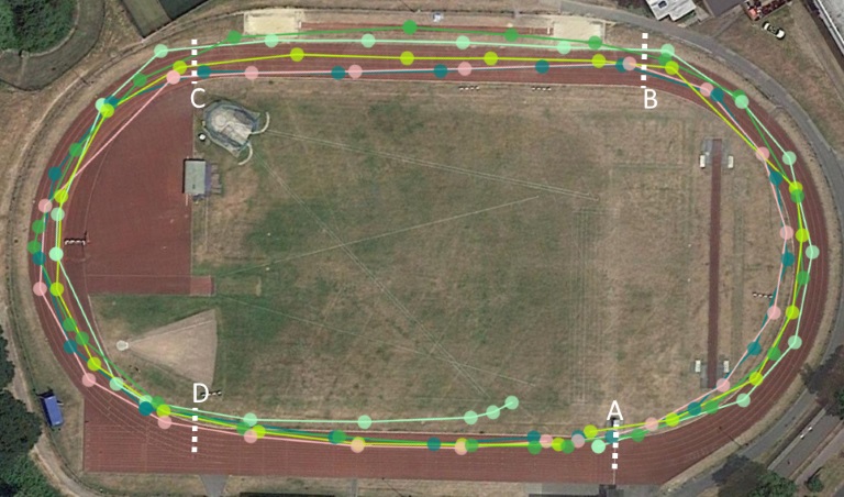
The 5 laps here are just a representative sample and they show some clear trends in how the GPS was able to track me through the activity, most noticeably how accurate it was every lap between points D and A where not a single lap went more than a couple of metres from the actual position (aside from the light green one that ends inside the track - that was the last lap and where I finished!). Also, this simple test shows how much better the activity tracked along straights than round bends. A-B and C-D are both similar in the spread of the track points and although B-C has a wider spread, all laps tracked a straight line which is correct.
Using this sample, we can also highlight the two main factors affecting the distance the GPS watch calculated.
The first factor, as covered earlier on, is the actual GPS accuracy itself which is tracking positions across the whole width of the track (and a few just on the inside). This 6-lane track is around 7.5 metres wide so that level of accuracy is what we would expect from a GPS watch. I was running on the inside lane most of the time, however there were other runners, so I did to move out to pass occasionally.
The second factor is the distance calculated between the track points. The lines joining the points are the distances that are calculated for this run, but they are not necessarily the exact route taken - As the track points are recorded every few seconds, the line between them appears to cut corners and turns a curve into a series of angles.
Above highlights the issue by simulating tracking a curve with frequent vs less frequent track points. The left had side has a more precise track round the bend of a running track for 100m and the right hand side has had 3 out of every 4 points removed which cut corners and the distance comes out to 99 metres - a 1% loss. Obviously you won't just be running round bends but small differences over the many turns in a long race do start to add up.
Given enough time, errors that add or subtract distance from the real distance travelled should roughly even themselves out to give a close calculation of the correct distance.
But what about those straights that don't seem to track accurately?
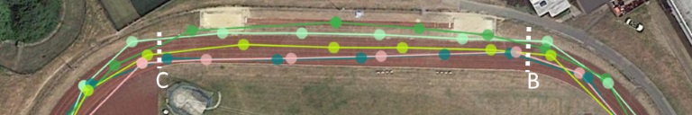
In the above section, each of the 5 laps tracked in a different position between points B and C but as they are all basically straight lines, it really doesn’t make much difference where they are positioned. All the lines are of very similar length between those points so they will all give the same distance travelled (within an insignificant margin for error for this level of detail).
We can even see the same thing involving corners too. Here is an example where the same section was run twice (during the same activity).
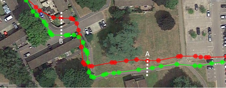
The green lap looks like it tracked more accurately to the path I was on, but the red lap has a very similar shape indicating that it followed the same path with a slight offset (that offset is due to the general GPS accuracy). The distance between points A and B is roughly equal on both laps despite the fact the positional difference.
Moving the red path so it sits closer to the ‘truth’ shows how similar they in fact are.
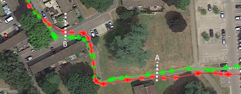
Both laps are now very closely aligned (bear in mind this map is zoomed a long way in, the distance from A to B here is only around 80 metres, following the path round the corners).
Activities can often start out with a little offset like the red lap here because the device doesn’t have a decent GPS fix (even if it sais it does) but over time will move closer to the accurate position. The distance gained or lost as a result of this happening will be unlikely to make any noticeable difference over a decent length activity - Maybe a few metres at most.
So, the distance my watch tells me is calculated this way?
It depends! The watch will use this technique as a base measurement, but it is able to use its own algorithm and can include data from any additional sensors it has in order to give a figure that it believes to be a more accurate value. The device can use things like cadence and altitude to tweak the distance based on the GPS alone - An example could go something along the lines of:
GPS based calculations came out to 15 metres between track points
But you took 2 more steps during that distance than normal at a constant cadence (most likely ran in a slight curve between track points rather than a perfectly straight line, so calculates the likely extra distance based on step count)
And altitude changed slightly (uphill or downhill adds a tiny amount, in the region of a few cm over this distance)
So the device may calculate that you ran a little further than the basic 15 metres and sets the distance travelled to, for example, 15.5 metres for that track point
This distance calculation is stored alongside the GPS positional data (as a running total, rather than the distance for that track point) so when the activity is finished, that value can easily be used to instead of working it all out again from track points.
But despite all the work to calculate the distance as accurately as possible, there isn’t a single agreed algorithm for this so everyone implements it differently.
And just like devices, software and services (Garmin Connect, Strava, Runkeeper, etc.) that you upload activities to may also use their own algorithms to calculate their own distance. You may notice that the same file used on multiple platforms can end up with slightly different distance between them. Differences should be insignificant, unless there is a problem with the file such as missing data, but it all shows that the GPS technology and interpretation of data isn’t 100% accurate in consumer devices.

This is a comparison between Strava and Garmin Connect for the same activity, note the difference in both distance and time due to the different algorithms used on each platform when analysing the activity. In this case, 'moving' time is important as it implies that there may have been sections of the track its algorithm decided to remove because I wasn't moving (at least not fast enough for Strava), it all has an impact on the overall numbers. The result caused a minor difference in the overall pace which could be important to you. Did I run this faster than 4:30/km or not? Depends where you look. Does it matter? It might to you.
Note: It took me a while to find an activity that had more than 0.01km difference (0.01k could just be down to rounding differences between the sites), the two are generally very consistent.
What factors affect good GPS tracking?
The limitations of GPS are well known, tall buildings, tree cover, etc. and they all appear to have a somewhat random effect on the GPS performance as we travel along any given path, but we can also observe instances where GPS has a strange habit of being ‘consistently inaccurate’.
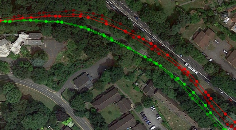
In this sample I ran along this path 6 times, 3 in each direction, reds were left-to-right and greens were right-to-left. You can see that each direction had a similar track that was followed each time. This is likely to do with the tree cover, the fact that just off the left-hand edge there is an underpass that I went through and it is the bottom of a hill - all things that limit direct visibility of the sky. To contrast that, off the right-hand edge is more open and at the top of the hill with good visibility of the sky. Together these affected the radio signals to give a slightly offset position, but a consistent one.
The best way to think about it is that the GPS device needs line-of-sight to the sky and therefore the satellites - Anything getting in the way can disrupt the signal and make it hard for the device to accurately calculate its position.
In my personal experience and referencing other people’s results, watches are very accurate - They can be trusted to keep your position to within 10 metres in a vast majority of cases and much more precise that than in many cases, its only when environmental factors get in the way that problems really occur. But when starting to analyse the data at the lowest level starts to show the limitations, don’t expect the distance tracked during an activity to be 100%, that tiny 0.5-1% error in distance may make a difference!
So of course, use your GPS watch during a run and use all the data you want afterwards (like that was ever in question) but be aware of the limitations.
Have a close up check of a race you have done in the past, does the time and distance match exactly with the published results?